

NABTEB GEOGRAPHY PRACTICAL
====================================
SECTION B
PART 1
_Answer two questions only from this part_
(1ai)
The scale of the map is 1:50,000
(1aii)
Old scale/New scale = 1/2
1:50,000/x = 1/2
x = 1:50,000*2
x = 1:100,000
The New scale is 1:100,000
(1b)
ANSWER LOADING……….
(1c)
South West Direction
(1d)
The drainage pattern is dendritic. It has many tributaries. River kunni is the major river flowing towards Northwestern direction
(1e)
(i) Farming due to the presence of scattered cultivation
(ii) Fishing due to the presence of rivers
(1f)
(i) Road transportation
(ii) Water transportation
(1g)
ANSWER LOADING……….
(1h)
ANSWER LOADING……….
====================================
(2a)
Sedimentary rock is a type of rock that forms at or near the Earth’s surface through the accumulation and solidification of sediment. Sediment can include pieces of other rocks minerals organic matter and even shells or skeletal remains of marine organisms.
(2b)
(i) Clastic or detrital sedimentary rocks
(ii) Chemical sedimentary rocks
(iii) Organic sedimentary rocks
(2c)
chemical sedimentary rocks: These rocks form when dissolved minerals in water undergo chemical processes such as precipitation to form solid rock. Examples include limestone dolomite and rock salt. Limestone is primarily composed of the mineral calcite which is derived from the shells of marine organisms such as corals algae and mollusks. It forms in shallow marine environments where the accumulation of organic matter and precipitation of calcite take place over long periods of time. Limestone often exhibits fossilized remains of ancient marine life making it valuable for studying Earth’s history and paleontology. Limestone is widely used as a building material for making cement as a raw material in manufacturing and for decorative purposes due to its durability and attractive appearance.
(2d)
(PICK ANY THREE)
(i) Natural resources
(ii) Water storage and aquifers
(iii) Fossil fuels
(iv) Geological history and research
(v) Landscapes and tourism
(vi) Soil fertility
====================================
(3a)
(i) Rainfall: Rain gauge or pluviometer
(ii) Humidity: Hygrometer or psychrometer
(iii) Temperature: Thermometer or temperature sensor
(iv) Wind speed: Anemometer
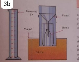
(3b)
Check the diagram below
(3c)
(i) Place the rain gauge in an open area away from trees buildings or other obstructions to ensure an accurate measurement.
(ii) Ensure that the gauge is level and stable to prevent any tipping or spilling of collected rainwater.
(iii) Read and record the initial measurement of rainfall on the graduated scale.
(iv) Leave the rain gauge undisturbed for a specified period (such as 24 hours) to collect rainwater.
(v) After the collection period carefully read the new measurement on the graduated scale.
(vi) Subtract the initial measurement from the final measurement to determine the amount of rainfall during that period.
====================================
(4a)
Mass movement refers to the movement of large amounts of material such as soil rocks and debris down slopes due to the force of gravity. It is usually triggered by factors such as the slope angle water saturation of the material vegetation cover and human activities.
(4bi)
(i) Landslides: Landslides occur when a mass of rock soil or debris rapidly moves down a slope. There are several types of landslides including rockslides debris flows and slumps.
(ii) Soil Erosion: Soil erosion refers to the gradual removal or displacement of soil particles from the land surface. It can happen through various processes such as sheet erosion rill erosion and gully erosion.
(4bii)
-LANDSLIDES-
(i) Rockslides
(ii) Debris flows
(iii) Slumps
-SOIL EROSION-
(i) Sheet erosion
(ii) Rill erosion
(iii) Gully erosion
(4c)
(PICK ANY FOUR)
(i) Destruction of Infrastructure: Mass movements can damage or destroy roads buildings bridges and other infrastructure in their path. This can lead to disruptions in transportation utilities and communication networks.
(ii) Loss of Life and Injury: Mass movements can pose a significant risk to human life especially during sudden and rapid events such as landslides. People caught in the path of mass movement may be injured or even killed.
(iii) Loss of Property: Mass movements can cause significant financial losses by damaging or destroying residential and commercial properties. This can result in the displacement of individuals and communities.
(iv) Environmental Damage: Mass movements can cause severe environmental damage by altering ecosystems destroying habitats and reducing biodiversity. They can also lead to soil erosion and sedimentation in bodies of water impacting aquatic ecosystems.
(v) Soil Degradation: Mass movements particularly soil erosion can lead to the loss of fertile topsoil reducing the quality and productivity of agricultural land. This can impact food production and agricultural economies.
(vi) Disruption of Water Resources: Mass movements can affect water resources by altering drainage patterns and causing the formation of new channels. This can result in flooding increased sedimentation and contamination of water sources with debris and pollutants.
=======================================
PART II
_Answer one question from this part_
=====================================
(5a)
GIS stands for Geographic Information System. It is a technological framework that combines geospatial data (data associated with specific locations on Earth) with software tools and hardware to capture manage analyze and display different types of information.
(5b)
(PICK ANY FIVE)
(i) Urban Planning: GIS is widely used in urban planning to analyze population distribution land use patterns transportation networks and infrastructure planning. It helps in making informed decisions about the development and management of cities.
(ii) Natural Resource Management: GIS enables the analysis and monitoring of natural resources such as forests wetlands and biodiversity. It assists in identifying suitable locations for conservation efforts assessing environmental impacts and managing resources sustainably.
(iii) Emergency Management: GIS plays a crucial role in emergency response and disaster management. It helps in mapping and analyzing areas prone to hazards locating emergency resources evacuations planning and assessing the impact of disasters.
(iv) Public Health: GIS is used in public health to analyze patterns of disease track the spread of epidemics identify areas at risk and plan healthcare facilities. It aids in understanding the relationship between health outcomes and environmental factors.
(v) Transportation Planning: GIS is utilized in transportation planning to analyze traffic patterns optimize routes plan public transportation networks and assess the impact of new infrastructure projects. It helps in improving efficiency and reducing congestion.
(vi) Environmental Impact Assessment: GIS is employed in assessing the environmental impact of development projects. It helps in analyzing sensitive areas modeling scenarios identifying potential risks and making informed decisions to minimize environmental harm.
(vii) Market Analysis and Location-based Services: GIS is used in market analysis to identify target markets assess consumer behavior analyze customer density and optimize retail store locations. It also forms the basis of location-based services like navigation apps and geolocation-based advertising.
(5c)
(PICK ANY THREE)
(i) Hardware: This includes computers servers storage devices GPS receivers and other physical equipment that is used to capture store and process geospatial data.
(ii) Software: GIS software provides the tools and capabilities for data management visualization analysis and modeling. Popular GIS software includes ArcGIS QGIS and Google Earth.
(iii) Data: GIS relies on geospatial data from various sources such as satellite imagery aerial photographs survey data and demographic information. This data is organized and stored in a structured manner to be used by the GIS software.
(iv) People: Trained professionals such as GIS analysts geographers and data scientists are essential for effectively utilizing GIS tools and interpreting the results. They play a crucial role in data collection analysis and decision-making.
(v) Processes: GIS involves a series of processes including data capture data integration data analysis modeling and visualization. These processes govern how data is collected managed analyzed and presented within the GIS framework.
=======================================
(6a)
Geographic data also known as geospatial data or spatial data refers to information that is associated with a specific location on Earth’s surface. It includes both qualitative and quantitative attributes related to the Earth’s physical features such as terrain climate vegetation as well as human-made structures and activities.
(6b)
(PICK ANY FIVE)
(i) Mapping and Navigation: Geographic data is used extensively for creating maps atlases and navigation systems that help individuals and organizations find locations plan routes and explore the physical world.
(ii) Urban Planning: Geographic data plays a crucial role in urban planning by helping to analyze land use patterns population density transportation infrastructure and spatial relationships. It aids in efficient city development infrastructure management and optimizing resource allocation.
(iii) Environmental Management: Geographic data is used for studying and analyzing ecosystems biodiversity and change in natural landscapes. It provides insights into climate patterns habitat conservation pollution monitoring and natural disaster management.
(iv) Emergency Response: Geographic data is utilized during emergencies like natural disasters and accidents for real-time situational awareness evacuation planning resource allocation and coordinating relief efforts.
(v) Market Analysis: Geographic data helps businesses and organizations to perform location-based market analysis. It enables them to understand consumer behaviors target specific geographic regions optimize sales territories and make informed business decisions.
(vi) Agriculture and Natural Resource Management: Geographic data is used by farmers agronomists and land managers to optimize agricultural practices plan irrigation systems analyze soil fertility and monitor crop health. It also aids in managing and conserving natural resources like forests water bodies and minerals.
(vii) Transportation and Logistics: Geographic data is critical for managing transportation networks optimizing logistics and improving supply chain efficiency. It helps with route planning traffic management fleet tracking and analyzing transportation patterns.
(6c)
(PICK ANY THREE)
(i) Satellite Imagery: Data collected from satellites provides high-resolution images and remote sensing data that allow for comprehensive analysis of the Earth’s surface including land cover vegetation and changes over time.
(ii) Aerial LiDAR: Light Detection and Ranging (LiDAR) technology uses laser scanning from aircraft to capture detailed information about the Earth’s surface including elevation terrain characteristics and structure.
(iii) GPS and GNSS: Global Positioning System (GPS) and other Global Navigation Satellite Systems (GNSS) provide precise geographic coordinates for mapping and navigation applications.
(iv) Government Databases: Various governmental organizations like national mapping agencies geological surveys and statistical offices collect and maintain geographic data related to infrastructure boundaries demographics land use and more.
(v) Open Data Initiatives: Many governments and organizations make geographic data freely available through open data initiatives allowing researchers developers and policymakers to access and utilize the data for various applications.
(vi) User-Generated Content: With the rise of social media and location-based services users contribute geographic data through geotagged photos check-ins and other location-based activities. This data can provide valuable insights into user behaviors and preferences.
COMPLETED
Leave a Reply